Germany is a federal republic made up of sixteen federal states. After notable periods of political upheaval over the last century, since the fall of the Berlin Wall and the re-unification of East and West Germany, the geographical borders of these states have remained stable and unchanged. For administrative purposes, these states are further divided into governmental districts, rural or urban districts, and municipalities.
Of the sixteen states, three are known as 'city states', covering the populous cities of Hamburg, Berlin and Bremen. The other thirteen are termed 'area states', and cover a larger geographic area. The full list is as follows:

Map of Germany states
Using thematic maps is a natural way to represent geographical data about a specific region. There are a number of common methods used by cartographers — a choropleth map for example would use the basic outlines of Germany and its constituent states to show the prevalence of specific data within these regions. Within these types of map, differences in qualitative data are shown by different colour hues, while quantitative data is represented by different hues of a single colour.
Other thematic map variants include proportional maps, where symbols of different sizes represent the value of data in that area, or dot distribution maps, where a dot is placed to signify each occurrence of a particular phenomenon. Methods such as these provide a quick at-a-glance review of what can be numerous or complex data sets.

Thematic Map was created with ConceptDraw PRO, it shows detailed maps for each of Germany's states, and vice versa extensive maps depicting Germany as a part of EU on the map of Europe
Using the diagramming software ConceptDraw PRO, in conjunction with the Germany Maps solution, gives users a powerful set of tools that allows them to quickly and intuitively create thematic maps based on Germany's national and district borders. The solution contains a professionally drawn map of Germany, with the ability to toggle the display of state borders and major cities, allowing further layers of detail to be added. As is common with ConceptDraw solutions, a number of templates and samples are provided to spark creativity and give map and infographic designers a solid base to start working from.
The ConceptDraw website provides in-depth learning materials and a comprehensive help desk, including video tutorials, FAQs, and how-to guides with simple to follow steps for the best possible results. Expand the borders of map and infographic design with the Germany Maps solution for ConceptDraw PRO.
Of the sixteen states, three are known as 'city states', covering the populous cities of Hamburg, Berlin and Bremen. The other thirteen are termed 'area states', and cover a larger geographic area. The full list is as follows:
- Baden-Württemberg
- Bavaria
- Berlin
- Brandenburg
- Bremen
- Hamburg
- Hesse
- Lower Saxony
- Mecklenburg-Western Pomerania
- North Rhine-Westphalia
- Rhineland-Palatinate
- Saarland
- Saxony
- Saxony-Anhalt
- Schleswig-Holstein
- Thuringia
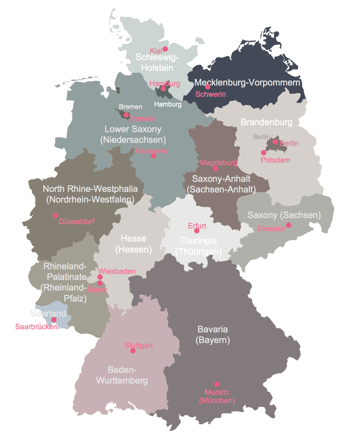
Map of Germany states
Using thematic maps is a natural way to represent geographical data about a specific region. There are a number of common methods used by cartographers — a choropleth map for example would use the basic outlines of Germany and its constituent states to show the prevalence of specific data within these regions. Within these types of map, differences in qualitative data are shown by different colour hues, while quantitative data is represented by different hues of a single colour.
Other thematic map variants include proportional maps, where symbols of different sizes represent the value of data in that area, or dot distribution maps, where a dot is placed to signify each occurrence of a particular phenomenon. Methods such as these provide a quick at-a-glance review of what can be numerous or complex data sets.
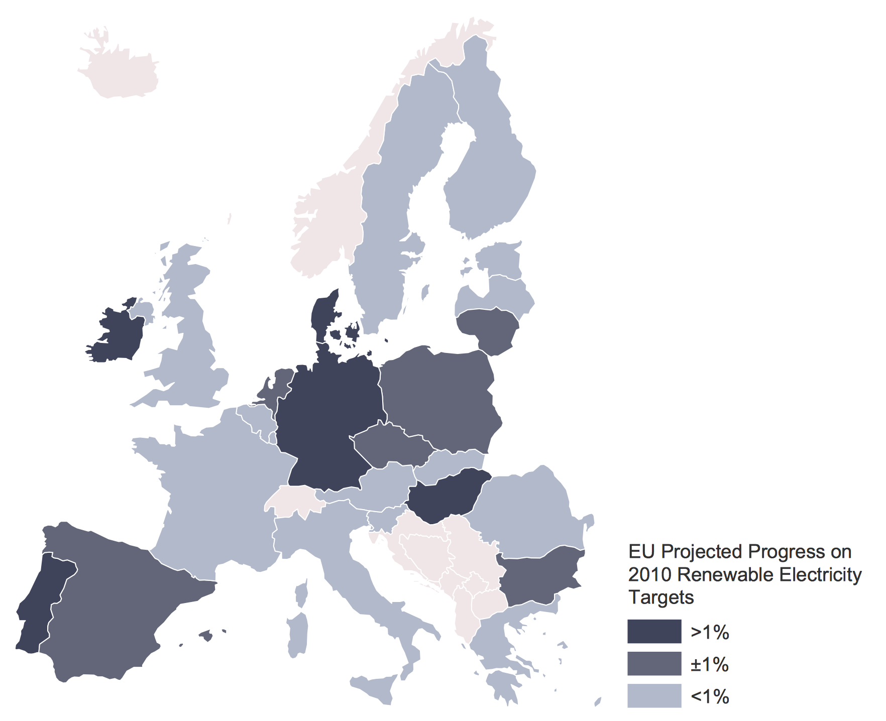
Thematic Map was created with ConceptDraw PRO, it shows detailed maps for each of Germany's states, and vice versa extensive maps depicting Germany as a part of EU on the map of Europe
Using the diagramming software ConceptDraw PRO, in conjunction with the Germany Maps solution, gives users a powerful set of tools that allows them to quickly and intuitively create thematic maps based on Germany's national and district borders. The solution contains a professionally drawn map of Germany, with the ability to toggle the display of state borders and major cities, allowing further layers of detail to be added. As is common with ConceptDraw solutions, a number of templates and samples are provided to spark creativity and give map and infographic designers a solid base to start working from.
The ConceptDraw website provides in-depth learning materials and a comprehensive help desk, including video tutorials, FAQs, and how-to guides with simple to follow steps for the best possible results. Expand the borders of map and infographic design with the Germany Maps solution for ConceptDraw PRO.